Calf Canyon Fire area at 168,008 acres, Cerro Pelado grew to 32,121 acres — critical weather expected
Overnight two major wildfires in New Mexico area increased area by about 6,000 acres. Hermits Peak and Calf Canyon Fire grew to 168,008 acres (165,276 acres on May 5), and Cerro Pelado Fire at 32,121 acres (29,368 acres on May 5). Almost 2,000 personnel involved in firefighting operations in total.
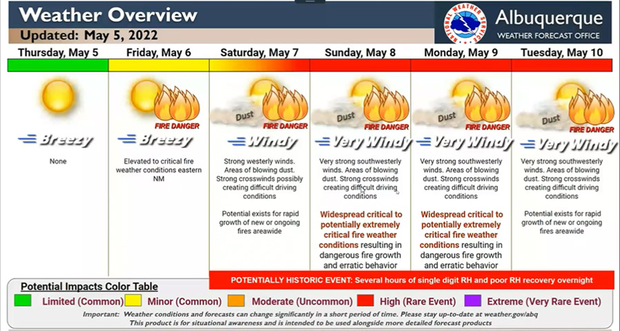
The National Weather Service in Albuquerque has issued a warning of extreme fire conditions across New Mexico. Strong winds and dangerous fire weather will exacerbate the fire threat. Widespread critical to extreme fire weather is likely on Saturday and Sunday, and possibly through Wednesday.
Overall, Calf Canyon fire behavior was active throughout much of the current fire perimeter. At the northwest corner of the perimeter, fire continued backing down to the 105 Road north of Gascon and continued backing downslope through mixed conifer and Ponderosa pine northwest of Vallecitos.
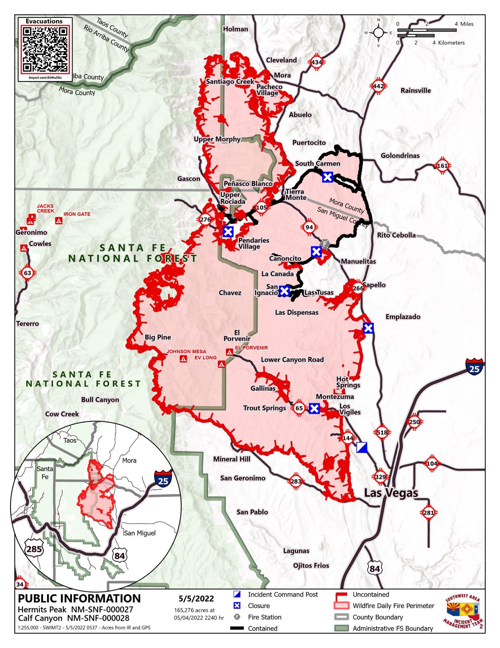
Ignition operations on the southeast portion of the fire continued to improve the depth of the previously completed burnout west of Las Vegas and north of the 283 Road, igniting unburned pockets of fuels and securing the area further.
Further upslope to the northwest, fire continued to back upslope from Calf Canyon, Tecolote Canyon, and Topside Canyon towards the crest of the Santa Fe range as well as continue to move south towards Goat Hill from Topside Canyon.
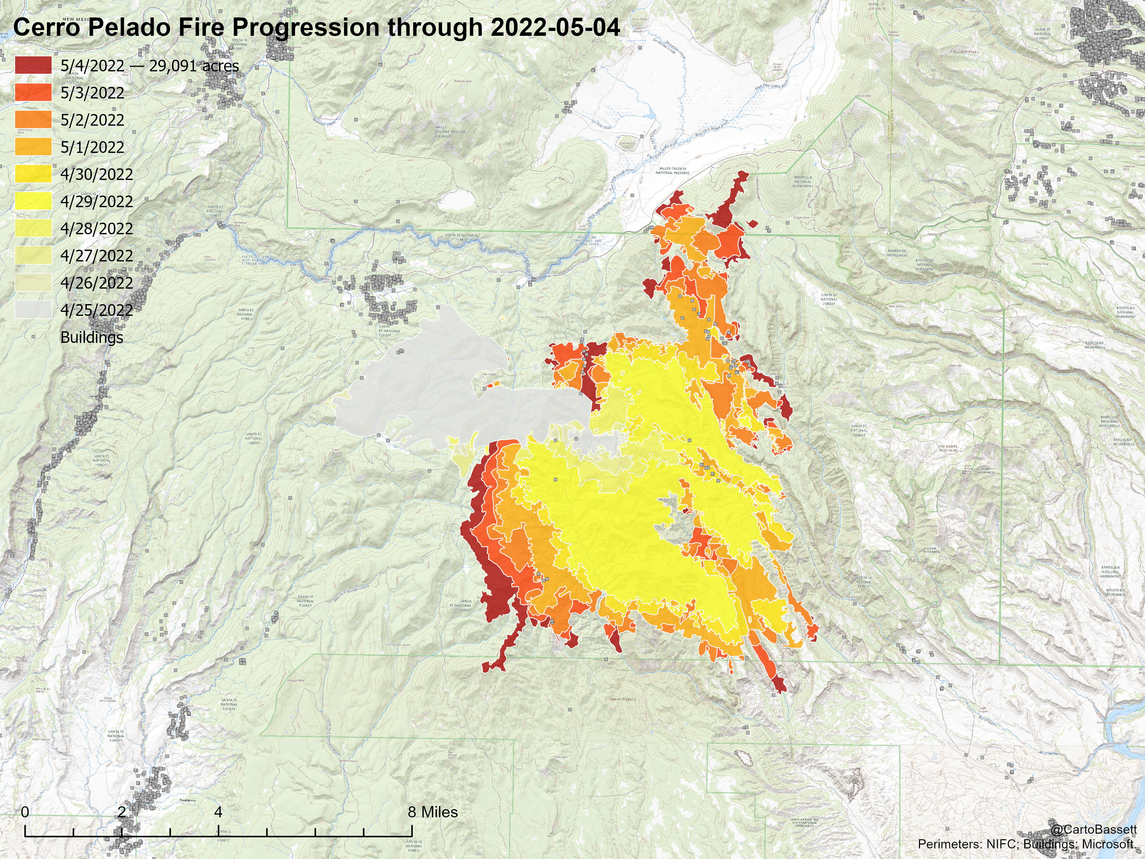
At Cerro Pelado firefighters continued to work long the perimeter of the fire along Highway 4 on the north, Forest Road (FR) 266 on the west, FR 270 on the south, and FR 289 on the east to improve firelines with thinning and chipping.
Planned actions for the Calf Canyon Fire:
Hold line South and West of Mora along the northern perimeter of the fire to reduce the potential of fire impacting Mora, Ledoux, Cleveland, South Carmen, and Bueno Vista
Patrol the 518 road, engage in structure protection for Canoncita, San Ignacio, Sapello, Las Tusas and Manuelitas. Prevent further structure loss within the fire perimeter. Prepare structures between the 518 Road and the fires edge to the west for the potential of northward fire progression beginning Sunday
Hold fire North of Highway 283, holding the Dozer line running from Storrie Lake to Bradner Reservoir and down to Highway 283
Prepare for structure defense in Ledoux, and prepare to engage in structure defense in Mora, Cleveland, South Carmen, Bueno Vista, Sapello, Las Tusas, Manuelitas, Emplazado, Gallinas, El Porvenir, Canovas Canyon, Big Pine, Rociada, Upper Rociada, Hot Springs, Holman and Mineral Hills.
Calf Canyon Weather Concerns:
West to northwest winds of 10 to 15 mph in the morning will increase to near 20 mph in the afternoon. Wind gusts will be between 30 and 35 mph. Maximum temperatures will top out from around 70 degrees in the upper elevations to the lower 80s in the lower elevations. Minimum relative humidity values will be 6 to 12 percent. The Haines Index will be a 6. LAL 1. CWR 0 percent.
Planned actions at Cerro Pelado Fire:
Hold fire south of Hwy 4 and west of FS RD 289 to stop progression to the northeast toward Los Alamos. Install and improve dozer lines along southern lines.
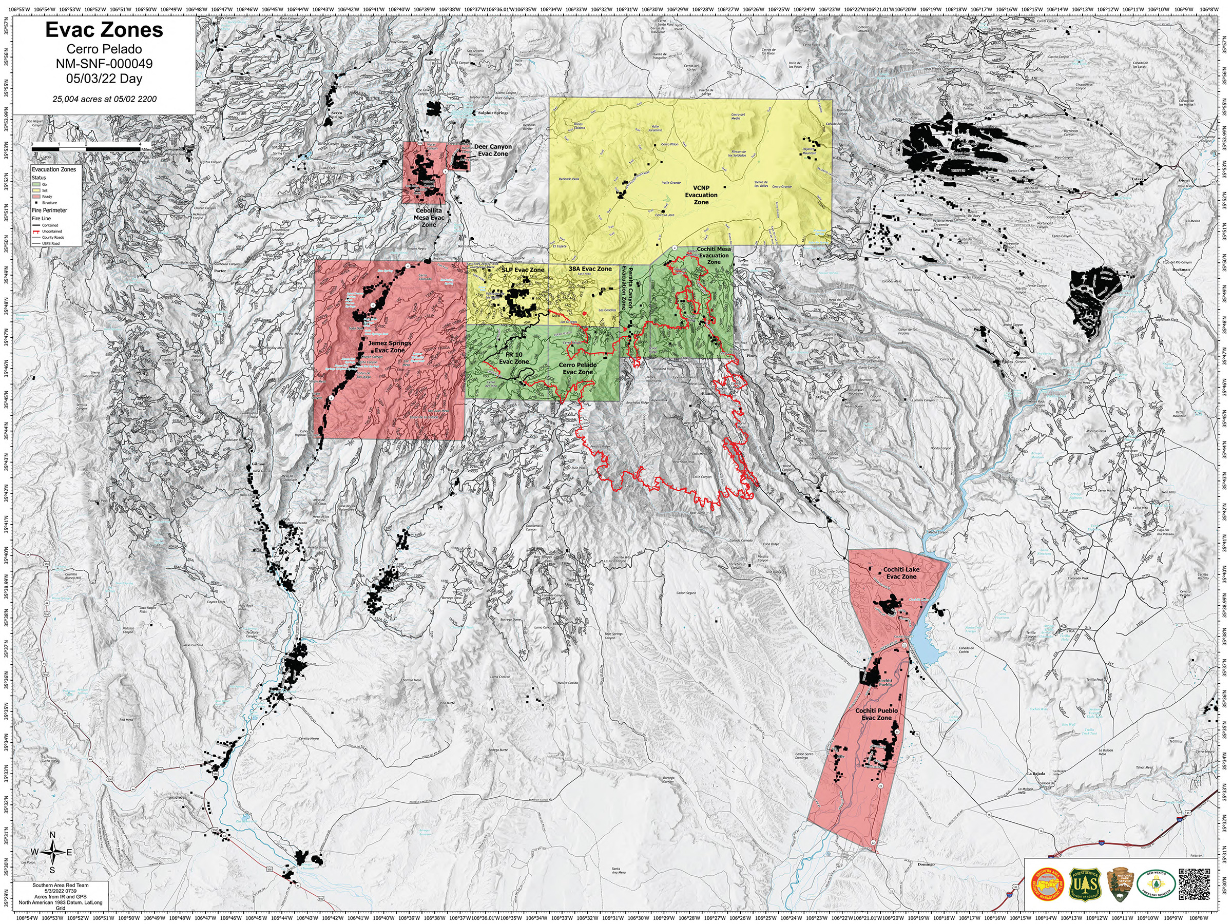
Cerro Pelado Fire Weather Concerns:
Temperatures a few degrees above normal (mid 60s), low afternoon RHs (low teens) and west-northwest winds (sustained around 5-15 mph with gusts near 25) occurred on Thursday. However, even slightly sheltered locations are expected to see diurnal wind flow dominate. As high pressure builds overhead, expect similar winds along with temperatures in the low to mid 70s on Friday. Dry air (near 10% minimum RHs) is expected to remain in place through the next several days with little chance of precipitation in sight.
Main concerns are several consecutive days of low daytime RHs and poor overnight RHs followed by a potentially significant multi-day strong wind event this weekend. A Red Flag Warning is already in effect for Saturday.